
X'cacel and X'cacelito are two "half moon" bays on Quintana Roo's coastline, between Akumal to the north and Caleta Xel Ha to the south. Inland they are bounded by a series of Pleistocene ridges running parallel to the coast. The area's main coastal highway, the Carretera Federal 307, has been constructed on one of these ridges and the land between the highway and the X'cacel and X'cacelito bays is owned by the University of Quintana Roo (UQROO). Due to the presence of marine turtles, which lay their eggs on the beach at X'cacelito and X'cacel, the area from the present day beach ridge out through the ocean to the dropoff has been established as a state Area Natural Protegida under the management of SEDUMA Quintana Roo. Much of the land between the present day beach ridge and the highway is low-lying mangrove or mixed-mangrove vegetation. This is believed to be important in protecting the water quality in the bays from sediment and nutrient runoff and from natural erosion, and is protected under Mexican environmental legislation.
Previous exploration inland of the highway had documented the presence of a large underwater cave system, Xunaan Ha , with about 33 km of interconnected passages running to about 5 kilometres inland. The cave explorers had shared their survey data with hydrological researchers, who found the cave useful as providing a transect for studying the dynamics of the aquifer. The explorers conducted a number of science dives to obtain water quality profiles and deploy instruments within the cave to collect data. However the downstream explored passages of Xunaan Ha terminated under the highway, opposite X'cacel, with nothing known about the final half kilometre to the ocean.
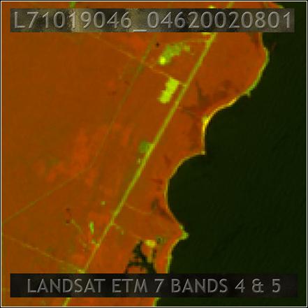 Vegetation differences at X'cacel/X'cacelito (the two bays in the centre) are visible on this Landsat ETM false
colour near infrared image. The darker areas close to the coast correspond to mangrove areas. Note Caleta Xel Ha to
the south.
Vegetation differences at X'cacel/X'cacelito (the two bays in the centre) are visible on this Landsat ETM false
colour near infrared image. The darker areas close to the coast correspond to mangrove areas. Note Caleta Xel Ha to
the south.
The economy of the region depends almost entirely on tourism revenues. Tourism is growing rapidly, which is driving rapid development of coastal land. The natural resources of the region (jungle, caves, cenotes, beaches and the ocean) are a major attraction for tourists. Development of the coastal land has the potential to adversely affect the natural resources, through its impact on surface vegetation and water quality in the aquifer and the bays, reducing the potential tourism revenues. Hence important management decisions must be made about the amount and nature of development which will be permitted, so that the economic potential of the natural resources is properly used to the benefit of the inhabitants of the region. Making those decisions requires an understanding of the linkages between the different ecosystems, such as those which arise from the transport of water between them. To understand those linkages we need information - "observations" in scientific terms - and we need theoretical models derived from those observations which can be tested and refined, so that we can make predictions about the likely impact of different management decisions.
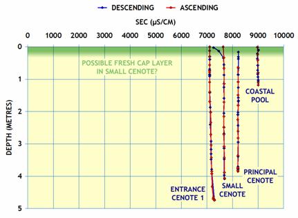 SEC (salinity) profiles in the freshwater layer at four cenote locations. SEC differences between the
locations are clear, with SEC increasing as the ocean is approached.
SEC (salinity) profiles in the freshwater layer at four cenote locations. SEC differences between the
locations are clear, with SEC increasing as the ocean is approached.
All of these factors combined to make a joint hydrological and speleological study of the Xcacel area of interest and relevance. In conjunction with SEDUMA Quintana Roo and UQROO, the researchers and cave explorers undertook a combined program of hydrological investigations and cave exploration on the X¿'cacel-X'cacelito property. That program included obtaining water quality profiles, deploying water level loggers, and exploring the caves to identify the major water flow routes.
Water quality profiles show what we would expect in the main flow system (the underwater caves) - there is a gradual increase in the salinity of the freshwater layer as we approach the coast, no doubt caused by progressive mixing with the underlying saline water. They also show a large disconnect between the surface waters - the water in the mangroves - and the underlying aquifer, suggesting that the mangrove areas constitute a "surficial aquifer" that needs to be understood and modelled separately from the underlying principal aquifer. The water level loggers have not yet been retrieved, but we hope that when they are the data from them will help us construct a numerical model of not only the flows in the principal aquifer, but the flows over the surface through the mangrove areas. The cave exploration - conducted principally by local cave explorers Mauro Bordignon and Alessandro Reato, with additional diving by explorer Bil Phillips - has been successful beyond our expectations, identifying and providing a high quality survey of over 4 km of underwater cave passages, and establishing a connection between those cave passages and the Xunaan Ha cave system immediately inland. At present there remains a 100 metre gap in the continuous cave system from Xunaan Ha to the ocean, and if the cave divers are unable to establish a cave connection then we hope to show at least a hydrological connection using a dye trace.
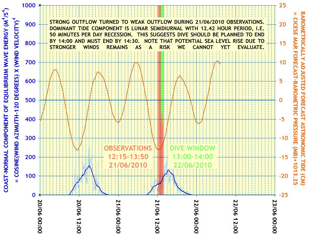
In the vent there are strong currents and small size passagges and this requires a careful study of tides to
minimize the effort on the way in and the risk of not being able to swim back to the exit.
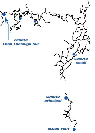
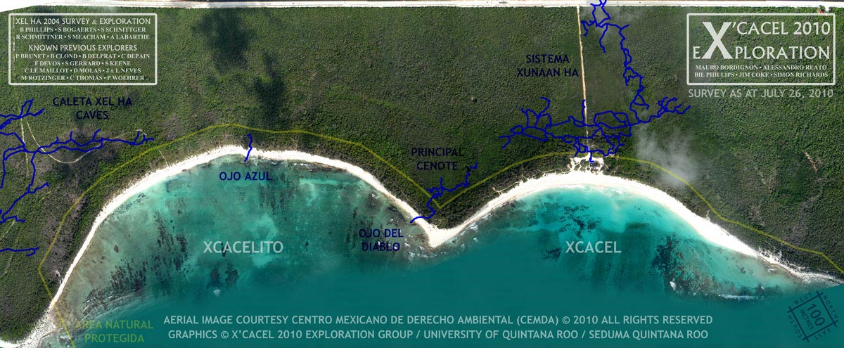 Caves explored as at July 26. Note that there remains a 100 metre gap between Xunaan Ha and the ocean
connection at Ojo del Diablo. Overall the picture which emerges is that flows enter the property from the inland
cave under the highway, continuing towards the coast, and then entering a region in which the principal cave
development is sub-parallel to the coast. This results in flows almost parallel to the coast towards Ojo del Diablo,
and possibly also onwards to Caleta Xel Ha.
Caves explored as at July 26. Note that there remains a 100 metre gap between Xunaan Ha and the ocean
connection at Ojo del Diablo. Overall the picture which emerges is that flows enter the property from the inland
cave under the highway, continuing towards the coast, and then entering a region in which the principal cave
development is sub-parallel to the coast. This results in flows almost parallel to the coast towards Ojo del Diablo,
and possibly also onwards to Caleta Xel Ha.